
About
Breathe Heathrow uses air quality sensors to help residents understand how the airport affects their area, bringing more data into the hands of communities to address local needs
Breathe Heathrow in a nutshell
London hosts some of the most polluted areas in the world. The city’s air pollution levels frequently breach EU safety limits and kill approximately 9,500 people annually as a result, according to King’s College London.
Heathrow Airport is the largest air terminus in the UK and is a major source of air pollution in London.
Breathe Heathrow is an air monitoring project run by Internet-of-Things company OpenSensors, designed to help Heathrow residents understand the air quality and noise impacts the airport has on their local areas.
With funding and support from the Open Data Institute, the Breathe Heathrow team deployed air quality and noise sensors in the gardens of volunteers who live around Heathrow – under windowsills, on the sides of sheds and beneath garden tables – to collect data that can help measure the environmental impact of the airport.
Through this project, Breathe Heathrow has shown local authorities how they can use data-driven open data methodologies for planning and development, and highlighted some challenges that come with building smart cities at scale.
Breathe Heathrow has proven that sensors depend on good connectivity, power supply and remote management. With enough sensors, careful deployment and peer-to-peer networks,community sensor projects and smart city initiatives can expand and have greater impacts.
Breathe Heathrow is ultimately a story of democratising data sources, encouraging the set-up of more community-driven sensor networks, rather than just institutional deployment, to bring more data into the hands of communities to address local needs.
The Breathe Heathrow team
- Yodit Stanton, Founder and CEO, OpenSensors.io
- James Moulding, Community Manager, OpenSensors.io
- Natalia Oskina, Junior Developer, OpenSensors.io
- S2DS PHD team
Background
According to King’s College London air quality research, London hosts some of the most polluted areas in the world. The city’s air pollution levels are continuously in breach of EU pollution legal safety limits year on year, and kill approximately 9,500 people each year as a result. The economic costs for the NHS and the country as a whole for supporting a high pollution economy can reach up to £54bn per year, according to the World Health Organisation.
With the UK’s largest air terminus in the UK on their doorsteps, Heathrow residents are concerned at ever poorer and more dangerous levels of air quality in the communities surrounding the airport.
Before beginning the Breathe Heathrow project, the OpenSensors team spoke to a number of residents surrounding the airport. Many said they were very irritated by noise levels and extremely concerned at pollution levels – especially during the summer months – as far out as Twickenham, Kingston, Brentford and Windsor. These areas had not been well-monitored for air or noise pollution, making the impact in those areas difficult to assess.
The immediate area around the airport is covered by some 14 automatic monitoring stations belonging to Heathrow Airport Limited (HAL), local authorities and the Department for Environment, Food & Rural Affairs (Defra). These cover areas such as Slough, Hounslow and Hillingdon and are also in the immediate vicinity of the runways. There is not much in the way of monitoring air quality outside of this chain of sensors.
The Breathe Heathrow team was interested in the spread and behaviour of pollution in these areas further from the airport, how it could be modelled, how secondary datasets – such as flight data, weather and local traffic data – could help them build a more concrete picture of air pollution in the area, combined with community produced air and noise data outside the immediate vicinity of the airport.
Breathe Heathrow offers a repeatable data-driven methodology and helps local authorities use data for urban planning and development. It also serves as a useful learning experience in how to foster bottom-up, open data-driven solutions for smarter cities, and highlights obstacles that similar initiatives may face in the future.
About the data
Residents around Heathrow are often negatively affected by noise or air pollution caused by the airport, but have been unable to access data to back up their position. This is mainly because air monitoring initiatives have been limited to certain areas around the airport, and the data they produce is not open for residents to access, use or share.
There are 14 automatic monitoring stations around Heathrow, which belong to Heathrow Airport Limited (HAL), local authorities and the Department for Environment, Food & Rural Affairs (Defra). These cover areas in the immediate vicinity of the runways but do not provide real-time data feeds and can only be accessed via an email-requested data-dump, which is neither machine accessible nor readable for real-time applications such as Citymapper.
Responsibility for air monitoring across the UK is spread in somewhat of a patchwork. The majority falls under Defra’s Automatic Urban and Rural Network with approximately 140 sites operated by Bureau-Veritas; the data is managed and processed by Ricardo AEA. There are a number of other sites owned by Defra and managed by Ricardo but run day-to-day by local authorities, and there is yet a further tier of stations affiliated to Defra but run and operated by various companies for local authorities.
Aside from this, roughly a third of UK air monitoring is entirely independent and managed on an authority-by-authority basis.
As I understand it, Ricardo AEA are – due to their contract with Defra – responsible for the distribution of air quality data... This means they currently handle the email request data-dumps and could be considered to be responsible for developing more modern and scalable methods of data distribution, such as APIs.
– James Moulding, Community Manager at OpenSensors and Breathe Heathrow team member
The Air Quality Expert Group, on which Ricardo sits, recently suggested they are looking into providing more up-to-date and accessible means of procuring data. Until that time, there are few publicly operated real-time and accessible air quality monitoring networks in the UK. The largest is King’s College London’s London Air Quality Network, and its data is available at OpenSensors.
There are number of independent, commercial and community-run air quality networks being established in the UK, such as the Air Quality Egg community, which is now partnered with OpenSensors.
Change London’s AirSensa – a project aimed at monitoring air quality at schools in London – promises to become another air quality data provider, having received a £1m donation from Addison Lee founder John Griffin. Other projects CleanSpace, BuggyAir and AirPublic are in their early stages of development, but promise to boost this area further.
The Breathe Heathrow challenge: making real-time data open and easy to understand
The challenge for this project was not only to publish the data openly in real-time, but also to organise the data for the open data community to use.
An important consideration for community open data projects like ours is delivering robust and structured tools that break down the barriers to data analysis.
– Yodit Stanton, Founder and CEO, Open Sensors
The data is hosted in the OpenSensors Breathe Heathrow Organisation. To bring its data to life, Breathe Heathrow also has a corresponding visualisation dashboard, showing how measurements vary over the cluster of devices, and over time for each device. The data is structured in a way that makes it easy to extract for visualisation.
The Breathe Heathrow tool allows users to drop into the dataset easily. By organising data by measurement type (CO<sub>2</sub>, NO<sub>2</sub>, temperature, humidity and noise levels) the team has been able to provide a structured open dataset.
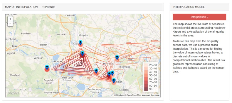
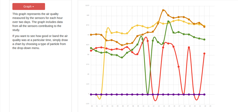
The dashboard developed by Breathe Heathrow includes contour maps of data and time-series charts. Providing context to the dataset can help to engage with a large, non-technical audience, and overlaying open data on maps can be extremely useful for planning. To do the latter, Breathe Heathrow used Mapbox. Its time-series charts were delivered through other open source libraries from Shutterstock and Gion Kunz.
Using open source code and open data resources together, and hosting code openly on GitHub, provides a lasting foundation for similar projects to reuse in future.
Methodology
In order to deploy the sensors needed for the study, the Breathe Heathrow team recruited people from around the Heathrow area with call-outs via social media, mailing lists and word of mouth. Groups like the Teddington Action Group, the Green Party and the Labour Party helped the team to find volunteers.
The team visited the participants over the course of a week and installed the sensors on the outside of their commercial buildings, beneath their windowsills, on the side of their sheds and beneath their garden tables.
On these visits, as well as installing the sensors, the Breathe Heathrow team also took them apart to show participants how they worked, trained them in accessing the data produced by OpenSensors, and explained basic principles of open data – data that anyone can access, use and share – and why they are important.
The sensors and how they work
The sensors used are Air Quality Egg V2s, modified to measure noise levels, provided by US-based Wicked Device. They produce data on temperature, humidity, noise, carbon monoxide levels and, importantly, NO2 levels.
This data is represented on a dashboard created by Breathe Heathrow, taking the form of graphs and real-time pollution dials for every sensor.
Putting air quality data into context
As Breathe Heathrow is able to increase the coverage and depth of air quality and sound pollution datasets around Heathrow, with more granular data from a larger deployment of sensors and a longer time-series – ie time spent collecting data – they aim to take this project further.
Combining this data with data on flights, weather, local traffic and other local sources of air pollution data such as Kings College London’s London Air Quality Network, Breathe Heathrow hope to be able to demonstrate causalities between datasets.
With strong winds, the local air pollution is lower; or for heavier planes (typically listed with a [HVY] prefix on flight datasets) the noise sensors may pick up higher noise levels in the vicinity of its glidepath – the route the plane takes when approaching a runway, or vice versa.
– James Moulding, OpenSensors
With frequent reports on how bad air quality is in London and notably around Heathrow – the intention of this government to allow for new capacity at Heathrow – I was interested in knowing how bad air quality already is where my family and I live, before it is allowed to get any worse. This is why I was keen to participate in this experiment and share the information openly.
– Local resident
Lessons learnt
Open data delivered via domestic ‘Internet-of-Things’ (IoT) devices, such as Breathe Heathrow’s air quality and noise sensors, is not always as robust as commercial or government data sources.
This is because cheaper IoT devices such as the Air Quality Egg or AirPi rely on inexpensive sensors, which are considered to be less accurate. However, this can be counteracted to some extent by calibration and good algorithms, as is the case for the Air Quality Egg. The Version 2 Egg, which [we] used, is far superior to the earlier design.
– James Moulding, community manager at OpenSensors and Breathe Heathrow team member
With a small team and limited resources, the Breathe Heathrow project came across several challenges to ensuring consistent data from its air quality and noise sensors.
To maintain its air sensor devices, Breathe Heathrow relied on a network of volunteers and a project manager to visit them and deal with issues such as wifi connectivity problems, minor hardware faults and software updates. This worked well in some cases, but not in others where volunteers with sensors did not follow instructions or guidelines.
Maintenance of sensors networks is complex and there are many points of failure. We learned that remote management and support is necessary going forward when dealing with community-driven projects.
Some participants changed their wifi router passwords, only to find their sensor, which was dependent on that connection, to then be non-functional. When this happened, instead of using the Egg’s interface to remedy the issue, a member of the Breathe Heathrow team had to venture out to make the simple adjustment. This level of maintenance would not be sustainable for larger deployments.
Software updating on the Air Quality Egg is another issue we have faced. We made minor adjustments to the Egg’s program in order to interface an additional sensor, a noise sensor to the platform. However, upon each software update we found that the update wiped our new configuration – requiring an intervention.
– James Moulding, OpenSensors
The Breathe Heathrow project experience has raised some important lessons for future sensor projects and rolling out similar smart city projects at scale.
Lessons learnt for sensor projects
Sensors are sensitive and faults limit data
Breathe Heathrow lost data due to hardware problems, power or device connectivity issues. For sensors to work at their best, devices should be carefully placed, out of the reach of toddlers, and have technical support on-hand to fix the sensors if they break. However, this can be difficult with limited resources.
Limiting sensors to areas with strong wifi connection can skew results
Choosing device hosts based on their connectivity can limit the coverage of a sensor project and exclude parts of the community, having negative impacts on the project and results.
Accurate data depends on a large sensor sample size
The sensor sample size needs to be large to make sure results are as accurate as possible. For small sample sizes, geographic interpolation plots are very sensitive to changes in readings, particularly observations made in outlying locations; lone sensors some distance from the main observation area potentially skew findings. It is important when designing network coverage that points of significant interest have dense coverage, with a large number of sensors. Increasing the number of sensors makes observations more robust, and means results are much less sensitive to sensor faults, but sensors are not always widely available for community sensor projects.
Recommendations for building a smart city at scale
Sensor networks need remote management and a purpose-built wireless network
Sensor deployments and networks should work in any environment or location and be insulated from their environment. Sensors should be location-agnostic and have their software remotely managed and updated, with wireless connectivity over a purpose-built network such as LoRA and sensors with their own power supply.
Smart city initiatives need to be informed by a range of open datasets
Data-driven methodology, bringing together a range of diverse datasets to measure ecosystems of causally related variables – in this case for improved monitoring of a serious public health issue – demonstrates the importance of a clear commitment to open data principles.
Collaboration
OpenSensors discovered the ODI showcase through talking to staff members at the ODI. OpenSensors was incubated as an ODI Startup for a period from October 2014 and maintains a strong relationship with the ODI, a natural partner to OpenSensors' real-time open data mission.
ODI funding was crucial to the project, financing the deployment of sensors and current and future data science analysis. The ODI has been invaluable in helping to shape and promote the story and develop our comms objectives.
What next?
The primary objective of the Breathe Heathrow project was to construct and test a data-driven methodology for air quality monitoring that can be extended to other fields and locations.
With the initial stage of project complete, Breathe Heathrow are now looking to expand the project, deploying a greater number of sensors to provide a more granular representation and including more secondary datasets upon which to correlate – datasets on air quality and traffic data, for example.
To keep costs down, the project focused on a community-driven approach. It encountered a number of issues, including maintaining connectivity and the problem of manually updating hardware in the field. As a result, over the next week Breathe Heathrow will be trialling LoRA, a peer-to-peer connectivity network, with several partners that include the Digital Catapultand the London tech community.
This kind of network will help ensure that future smart city initiatives can deploy sensors in more environments and locations, as they would rely less on site visits and their software could be remotely managed and updated.
Over the coming months, Breathe Heathrow will work to improve upon the foundation it has laid and encourage others to use this open methodology and build a community of best practice in air quality sensing. A number of groups are already replicating the project or considering it, including air quality-focused startup AirPublic and the Canadian city-authority of Oakville, Toronto.
OpenSensors’ Breathe Heathrow project will continue to gather data around Heathrow and is looking to recruit volunteers to the project to help further build our understanding of air quality in the area.
Get in touch or tweet @opensensorsio to find out how to get involved.