
The Open Marine Data project is supporting emergency responders to improve access to the data that they collect, to enable innovators to create new tools and approaches and to support emergency responders to make better decisions.
Back in March 2020, the Lloyd’s Register Foundation and the ODI offered a stimulus fund to help projects to increase access to data and drive innovation in the engineering sector – with an emphasis on improving safety, and this is one of them.
As an island nation, the UK sees numerous coastal incidents and emergencies every year. In 2019, Royal National Lifeboat Institute (RNLI) lifeguards responded to 17,356 incidents near the shore and lifeboat crews launched 8,941 times to respond to incidents further out at sea.
While the RNLI is the primary responder to emergencies at sea, the organisation only responds to around 50% of incidents; with Police, Fire and Rescue,Ambulance Services, the Air Ambulance Association and other private organisations also playing a role in search and rescue operations. With so many organisations playing a role in saving lives at sea, it is integral that all of these organisations have access to the necessary tools and information in order to respond to incidents in the most effective and timely way.
All ‘999’ emergency calls that concern safety at sea are received by the Maritime and Coastguard Agency (MCA) and then a decision is made as to which emergency responder is most appropriate to address the situation. While this initial decision is made in a time efficient way, there is no automated process to send data about emergency events, –such as location or type – to the relevant authority, which can cause delays in effective decision making by the team that needs to respond to the emergency. Access to data and information can be critical in an emergency situation, and therefore the infrastructure that enables organisations to share data must be fit for the purpose of responding to emergencies as well. Taking better approaches to sharing data, such as using a common system or adopting the same standards for data, can improve the efficiency of real time sharing of data. Making some of this data available under an open licence would allow anyone to access, use and share it, which could enable innovators to create new tools and approaches to support emergency responders to make better decisions.
The Open Marine Data project, led by the GeoData Institute based at the University of Southampton, is supporting emergency responders in the marine sector to improve access to the data that they collect, with a view to providing an open marine dataset for use by the whole sector. The project is funded by Lloyd’s Register Foundation through the Open Data Institute (ODI), as one of four stimulus fund projects that promote the access and use of open data, with an emphasis on improving safety.
What was the challenge?
The Open Marine Data project builds on GeoData’s previous work in the Big Marine Data Project (BMDP), another initiative funded by Lloyd’s Register Foundation. The BMDP identified an urgent need to develop protocols, standards and platforms for sharing incident and response data relating to coastal and marine safety. One of the main observations from the project was that effective sharing of data is critical for emergency responders to fully understand the incident at hand, both at the time of the incident and thereafter, but that often, there is a mismatch in the data being shared between the relevant agencies and that this does not always happen in the most efficient manner.
The MCA currently collects a record of all emergency calls in a proprietary system called ‘Vision 4’. While the system is suitable for data collection, due to technical constraints, it does not allow data to be easily shared with first responders. As the major stewards of data around coastal emergency responses, both the RNLI and MCA have been exploring ways to share data more effectively, which has included the creation of data sharing agreements between the two organisations, but there has been no actual sharing of data to date.
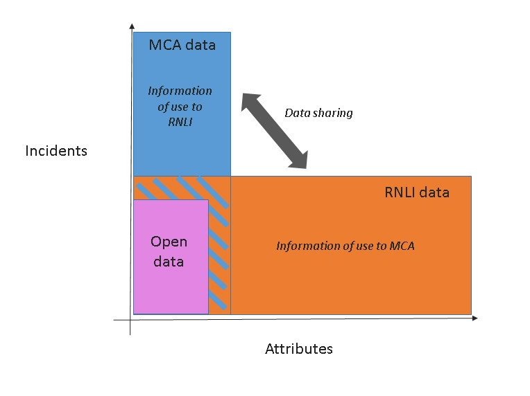
Figure 1 shows the potential for data sharing between MCA and RNLI. The MCA holds all of the data about incidents and RNLI respond to approximately half of these incidents. By contrast, RNLI append a large number of attributes to an incident during and after the rescue, that are not conveyed back to MCA. Data sharing between the two organisations would close these gaps.
There are some databases available that provide free access to water incident data, such as the Water Incident Database (WaID), which is stewarded by the National Water Safety Forum, a voluntary network committed to promoting water safety by sharing information. While the WaID is a useful source of information and includes some information not captured by most coastal agencies, such as statistics on freshwater incidents, the database does not provide sufficiently detailed information to help emergency responders to identify success factors in rescue missions.
How are they solving the problem?
The GeoData team has identified two opportunities as part of the project:
- There is an opportunity to improve data sharing between RNLI and MCA about coastline incidents
- There is an opportunity to create a blueprint - or a technical outline - for an open marine incident dataset
Improving data sharing
At present, the MCA and RNLI capture two separate records of what happened with a particular incident. These two records should be identifiable by a Global Incident Number (GIN), which should be connected to both records and should make it easier to join the two records together, but GIN numbers are not always consistent with each other, with around 3% of GIN numbers being inconsistent across both records, usually due to human error. Without unique identifiers to connect the two records, an automated data sharing process is not currently feasible. In order to address the inconsistencies, MCA are looking to adopt the Multi Agency Incident Transfer (MAIT) schema, a standard UK Government format for sharing incident data that enables direct device-to-device data transfer without the need for human involvement.
Creating a blueprint for an open marine dataset
In order to improve access to data across the marine sector, the team at Geodata have created a blueprint - or a technical outline - for an open marine incident dataset. There are two proposed stages to developing the proposed open marine dataset.
Firstly, access to data amongst first responder agencies, in particular the RNLI and MCA, must be improved by enabling better data sharing. User engagement has shown that each agency would find the data collected by others to be valuable in helping them to see the full picture of a particular incident, which could lead to improvements in service delivery and operational efficiency gains. For example, the RNLI might find information about where they are not required to respond to a situation useful, as this could help to better inform resource management.
Secondly, the data must be cleaned and standardised. The data must be anonymised before it can be made publicly available. The MCA collects data about incidents across the world, so before a new open dataset can be created, the data must also be cleaned to make sure that the new dataset is representative of UK coastal and near-shore incidents only. The RNLI already publishes open incident data, but this data contains a lot more attributes than the MCA data. Sharing similar, but different attributes between organisations could confuse or contradict the information held by the other organisation, so there needs to be a data standard adopted by both organisations to guide which attributes should be included in the new open marine dataset.
The table below outlines what an open marine dataset could look like if standardised attributes were recorded and the MAIT schema was adopted:
| RNLI data: | MAIT XML Tag: | MCA data: |
| rnli_orig (new field) | <OrigOrganisation> | mca_orig (new field) |
| rnli_dest (new field) | <DestinOrganisation> | mca_dest (new field) |
| DateOfLaunch | <OrigIncidentDate > | CREATION_DATE |
| Vessel | <VesselName> | Vessel_Name |
| ReasonForLaunch | <Description> | REVISED_INCIDENT_TYPE |
| X | <X> | X |
| Y | <Y> | Y |
| LaunchTime | <OrigIncidentTime> | ASSIGN_TIME |
| W3W (new field) | <CallerGazRef> OR <Location> | W3W (new field) |
| GRADE | <new_tag> | GRADE |
| ZONE | <new_tag> | ZONE |
| AIC | <new_tag> | AIC (new field) |
| LifeboatStationNameProper | <new_tag> | LifeboatStationNameProper (new field) |
| YearOfCall | <new_tag> | YearOfCall (new field) |
| LifeboatClass | <new_tag> | LifeboatClass (new field) |
| LifeboatNumber | <new_tag> | LifeboatNumber (new field) |
| RoSType | <new_tag> | RoSType (new field) |
| CasualtyCategory | <new_tag> | CasualtyCategory (new field) |
| CasualtyTypeFull | <new_tag> | CasualtyTypeFull (new field) |
| OutcomeOfService | <new_tag> | OutcomeOfService (new field) |
| Activity | <new_tag> | Activity (new field) |
| VisibilityAtIncident | <new_tag> | VisibilityAtIncident (new field) |
| WeatherAtIncident | <new_tag> | WeatherAtIncident (new field) |
| SeaConditionsAtIncident | <new_tag> | SeaConditionsAtIncident (new field) |
| WeatherAtLaunch | <new_tag> | WeatherAtLaunch (new field) |
| VisibilityAtLaunch | <new_tag> | VisibilityAtLaunch (new field) |
| WindDirectionAtLaunch | <new_tag> | WindDirectionAtLaunch (new field) |
| SeaConditionsAtLaunch | <new_tag> | SeaConditionsAtLaunch (new field) |
| ROSNumber | <new_tag> | ROSNumber (new field) |
| GlobalID | <new_tag> | GlobalID (new field) |
| CreationDate | <new_tag> | CreationDate (new field) |
| Creator | <new_tag> | Creator (new field) |
| EditDate | <new_tag> | EditDate (new field) |
| Editor | <new_tag> | Editor (new field) |
| Requires development to extend MAIT schema |
Table 1 – RNLI mapped to MCA data using MAIT schema
The fields in the left-hand column contain attributes already included in the RNLI open dataset. All fields in white are currently collected and used by either the RNLI or MCA. The fields in yellow are those that need to be developed in order to complete the full picture.
What could be the impact of taking this approach?
With the development and implementation of the schema outlined in the table above, data could be shared both ways between MCA and RNLI. This would mean that RNLI could receive attribute information automatically when an incident occurs. It would also be possible for RNLI to immediately receive the location coordinates of the initial call. Similarly, when data records are shared back to the MCA, the rescue location coordinates could be added to the MCA system.
The implementation of the schema would resolve most of the current issues that prevent data from easily being shared, such as:
- Manual sharing of time sensitive data
- Ambiguity around the location of an incident
- A lack of common understanding around attributes
- A lack of clarity about which events RNLI should respond to (instead of other emergency response agencies)
- Unnecessary time and expenditure on manual handling of data
Interview with Southampton University on the project
What lessons did they learn?
The Open Marine Data project commenced at a time when Covid-19 started to have a real impact on the way that we all interact with each other. This presented some early challenges to the GeoData team in being able to work collaboratively with the RNLI and MCA teams, as all three organisations started to adapt to a different pattern of working during the pandemic. This meant that implementation of the open marine data blueprint, while part of the original scope of the project, was not feasible within the timeframes of the project. However, the team learned to overcome some of these early collaboration difficulties by working with both organisations to create a new Joint Technical Working Group, which aims to achieve a common goal of enriched information for both parties, as well as work more collaboratively across a number of other areas. The working group demonstrates a commitment from all organisations to make a complete open marine incident dataset a reality – despite all of the difficulties with remote working.
What’s next?
Harmonising Marine Incident data among first responder agencies is no easy task, otherwise it would have been achieved and implemented long ago. Despite this, there is a firm recognition that data sharing is mutually beneficial to agencies involved and while there are technical challenges to overcome, the Open Marine Data project has been a catalyst to the progress made so far. Looking forward, the project recommends the following:
- Continue with the momentum gained from the first meetings of the Joint Technical Working Group.
- Work closely with British APCO who develop the Multi Agency Incident Transfer data standard.
- Implement the MAIT data standard in both MCA and RNLI command and control systems.
- Extend Geographical Markup Language (GML) to develop a universal open data standard for Marine Incident Data (perhaps ‘Marine Incident Markup Language’ (MIML)).
With the Joint Technical Working Group sessions set to continue throughout 2021, in the long term it is hoped that the work done by the Open Marine Data project has laid the foundations for the development of an open marine incident data standard, which can be adopted by other emergency responders working in the marine sector.